Colorful dawn sky on Saturday near the Memorial Bridge. (Jeanne Stuart McVey/Flickr)
Always a human at the helm: Updated around-the-clock by Capital Weather meteorologists.
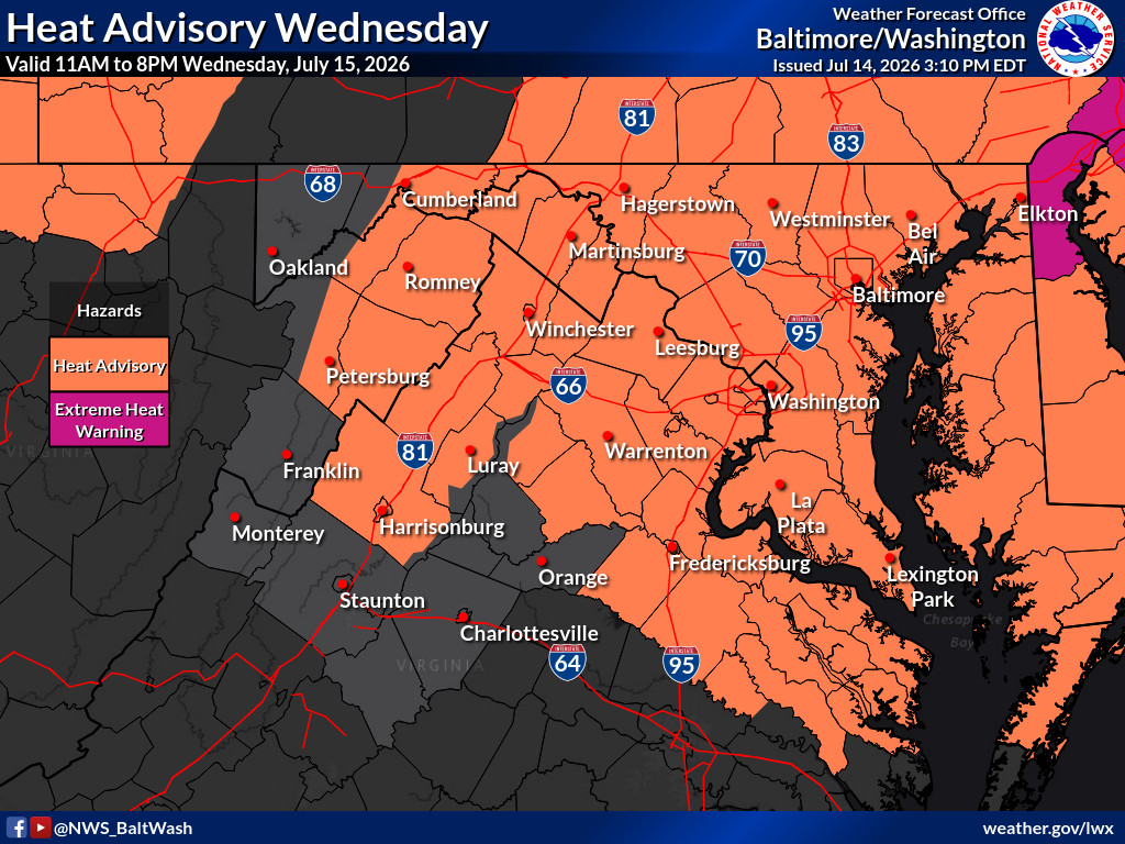
Happening now: Quickly rising through the 70s and 80s this morning. Most spots are near or above 90 before noon. Heat advisory starts at 11 a.m. with sizzling afternoon highs in the upper 90s to low 100s as the heat index peaks near 105.
SHOW RADAR & ALERTS MAP
Severe T'storm Warning
Tornado Warning
Flash Flood Warning
Hover a warning for details
👆Tap a warning for details
—
What’s next? Almost or as hot tomorrow, with a smoky haze possible. A bit less hot Friday and more so this weekend. Both weekend days have a chance for scattered showers and storms at some point.
Today’s daily digit — 0/10: Extreme heat. No likey. | 🤚 Your call? The digit is a somewhat subjective rating of the day’s weather, on a 0-to-10 scale.
Forecast in detail
Today (Wednesday): Mostly sunny and extremely hot with high pressure entrenched overhead. Highs head for the upper 90s to low 100s with the heat index peaking near 105 thanks to high humidity (dew points near 70). Winds come from the west around 10 mph. The record highs for the date are 102 in DC and at BWI, and 99 at Dulles. There could be some wildfire smoke in the air today but most of it should stay elevated well above the ground level, limiting its impact on air quality. Confidence: High
Tonight: Evening readings slowly fall back through the 90s under mostly clear skies. Continued muggy overnight with lows in the mid-70s to near 80. Confidence: High
Tomorrow (Thursday): Partly to mostly sunny with temperatures soaring once again. Highs look like the upper 90s to near 100. However, there is some potential for wildfire smoke to hold readings back a couple of degrees, in which case some spots could stall in the mid-90s. This time, there's a better chance of smoke closer to ground level that reduces air quality. Light winds variable in direction in the morning come from the west around 10 mph again in the afternoon. Just a slight chance of a late afternoon or evening thunderstorm. Confidence: Medium-High
Tomorrow night: Slight chance of an evening thunderstorm. Otherwise it's another steamy evening with temperatures dropping back through the 90s into the upper 80s under partly cloudy skies. Remaining muggy overnight with lows in the mid- to upper 70s. Confidence: High
📬 Get our forecast in your inbox
Our morning forecast email is back! It's included with every level of support — from Free to Founder — delivered 7 days a week. Sign up at: capitalweather.com/support-us
A look ahead
We should take the edge off the heat just a bit on Friday, as the dome of hot high pressure starts to retreat. Highs aim for the low to mid-90s with partly to mostly sunny skies. Humidity should come down a bit as well. Could see a few showers or thunderstorms pop up Friday evening or overnight with lows around 70 to 75. Confidence: Medium
Pretty typical temperatures this weekend with highs in the mid-80 to low 90s. With lower pressure and humidity trending higher again, both days have a chance for scattered showers and storms at some point, especially during the afternoon into evening. Saturday night lows in the upper 60s to low 70s. Confidence: Low-Medium
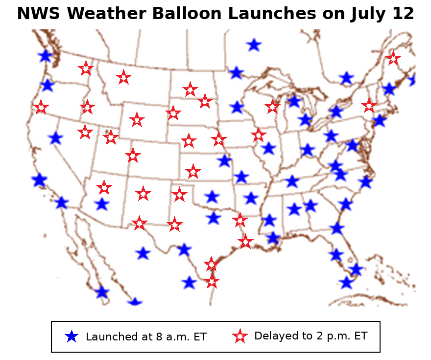
A weather balloon being taken out for launch. (National Weather Service)
Meteorologists are expressing growing concern about the impact of reduced or delayed weather balloon launches, warning that the missing data may be making severe weather forecasts less reliable. Weather balloons provide some of the most valuable data used in forecasting.
The National Weather Service, which is responsible for the launches, maintains that the lack of balloon data hasn’t degraded forecasts, but forecasters are frustrated by a dearth of research assessing the impact of the missing data following a handful of high-profile forecast misses in recent months.
Each weather balloon carries a radiosonde, an instrument that transmits measurements of temperature, humidity, air pressure, wind speed, and wind direction as it rises through the atmosphere. Observations from different levels of the atmosphere are critical to weather forecasting, especially for predicting whether thunderstorms will develop and how strong they might become.
The reduced balloon launches began in March 2025, when the Weather Service cut launches from twice daily to once daily at six locations because of staffing shortages. The following month, the Weather Service issued a notice saying launches could be temporarily reduced or suspended at selected sites “due to staffing limitations or operational priorities.”
“Under normal operations, the NWS conducts and/or supports radiosonde observations twice a day from 100 upper-air sites throughout the United States, Caribbean and Pacific Basin,” the agency said in the notice.
Staffing shortages have persisted since the Weather Service lost about 600 employees through Trump administration layoffs and buyouts last year, CBS News reported last week, even after President Trump granted an emergency authorization last August allowing the agency to hire 450 people over a one-year period ending this September.
While most sites are back to launching twice a day, launches at more than 25 locations are routinely being delayed from the early morning to the middle of the day, according to a Capital Weather analysis of upper-air data archived by the Weather Service’s Storm Prediction Center. The absence of morning balloon data became especially pronounced across a large portion of the western United States beginning in April of this year. Because weather systems often move from west to east, it’s possible the missing data could impact forecasts farther east.
Based on maps from the National Weather Service's Storm Prediction Center. Adapted by Capital Weather.
In a statement to Capital Weather, Weather Service spokesperson Erica Cei said the agency has seen no evidence of an impact on forecasts, and that its models are not as reliant on data being collected at a specific time because they incorporate data gathered over the course of several hours.
“NOAA weather model performance has shown no evidence of degradation,” Cei said. “Our observing system is incredibly resilient with many redundancies, and we continue to expand our observational network by including more observations from the commercial sector, both at and in between traditional NWS upper-air sites.”
Although the Weather Service as of June had hired more than 300 of the 450 new employees authorized last August, according to the CBS News story, Cei told Capital Weather the agency doesn't have an estimate for when the delayed launches will be restored to their normal time.
Some meteorologists are pushing back on the Weather Service's assertion that forecasts haven't been impacted by gaps in balloon data. Politico reported last week that meteorologists and an emergency manager believed missing morning weather balloon data contributed to a poorly predicted tornado outbreak on April 13, near Kansas City, Kansas. The Weather Service issued a tornado watch only about 30 minutes before the first tornado. Such watches are issued when forecasters determine that atmospheric ingredients are in place that could lead to tornadoes.
In an April story about the same incident, NBC News reported that “many forecasting offices in the Great Plains did not launch weather balloons at 7 a.m. Monday, as they have for decades, and instead they released the balloons at noon,” too late to be incorporated into models that are timed to run shortly after 7 a.m.
Alan Gerard, a meteorologist who served in various leadership positions during a 35-year career at the National Oceanic and Atmospheric Administration, said the missing balloon data may have contributed to the poor model forecasts while acknowledging that thunderstorm and tornado forecasts are challenging even with the best data.
“I am not claiming that the lack of NWS balloon data upstream of these storms is the definitive reason for this poor forecast,” Gerard wrote in an analysis on Substack. “What I am saying, though, is that as an experienced meteorologist … it is hard for me to imagine that it does not have some negative impact on those model forecasts.”
Capital Weather meteorologist Matthew Cappucci, who frequently chases storms in the Plains and Midwest, said the gaps in weather balloon data are particularly troubling on days when there is potential for severe weather.
“We can’t go 18 hours without ascertaining how the atmosphere is layered, how much storm fuel has built up and if severe thunderstorms are going to erupt,” Cappucci wrote on X. “As an atmospheric scientist myself, I can say firsthand — the forecasts I’m able to offer you are less accurate than they would otherwise be. I’m not able to predict severe weather with the confidence I normally would. That is extremely concerning.”
Cei pointed to the growth of satellite observations and other data in recent decades as mitigating the impact of delayed balloon observations, noting that weather models ingest data from satellites, commercial aircraft, surface stations, radar, buoys, and other sensors in addition to weather balloons.
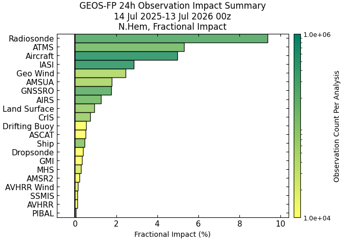
But NASA data from the past year show that radiosonde data from weather balloons were the most impactful observation type collected in the Northern Hemisphere. Their impact on a global measure of 24-hour forecast accuracy was roughly twice that of aircraft observations or any individual satellite instrument.
A NASA analysis showing that, among observations collected in the Northern Hemisphere, weather balloon radiosonde data made the largest contribution to reducing error in 24-hour global forecasts. (NASA Global Modeling and Assimilation Office)
Yet the extent to which missing or delayed weather balloon data is affecting severe weather forecasts at a regional or local level remains difficult to quantify.
“Our view is that it may impact closer-by forecasting in the Plains, but less so in the Eastern U.S. Balloons are a very small percentage of the global dataset being used these days,” said Capital Weather meteorologist Matt Rogers, who also heads Commodity Weather Group, a private forecasting firm focused on the energy and agriculture markets. “Unfortunately, there is no way to know when and which situations would have been helped by balloon data, since we can’t go back and test the 'with data' versus 'without data' scenarios.”
That lack of quantifiable data is what frustrates Matt Lanza, a longtime meteorologist in the energy sector and managing editor of Space City Weather in Houston.
“Are satellites really doing the job well enough? We need to know. I've seen more than one instance of localized forecast busts in Houston, the Mid-Atlantic, Midwest, and elsewhere over the last 18 months, but I'm not sure if those are normal [thunderstorm forecasting] challenges or if it's directly related to the degradation of data,” Lanza told Capital Weather. “I've truthfully grown exasperated waiting for some sort of decisive answers.”
Days at or above 100 so far this year across the region. DC has had four. (Capital Weather via ACIS)
With highs forecast to flirt with the century mark Wednesday and Thursday, DC's total of 100-degree days this year could climb even higher up the record books.
DC currently has four days at or above 100 degrees, tied for the eighth-most in any year since modern records began in 1872. A fifth 100-degree day would move this year into a tie for sixth, while six would tie for fourth.
Years with as many or more 100s than 2026
2026 has 4; these years matched or exceeded that mark.
1930
11
2012
8
1988
7
2024
6
1980
6
2011
5
1997
5
2026
4
2016
4
2010
4
1993
4
1954
4
1874
4
If DC reaches 100 on Wednesday, it would also tie the record for the most 100-degree days through July 15—the midpoint of meteorological summer—with five, set in 2012.
This year is also on pace to join a select group in another way. Twelve years have recorded three separate 100-degree heat waves, with cooler periods in between. This summer appears poised to become the 13th.
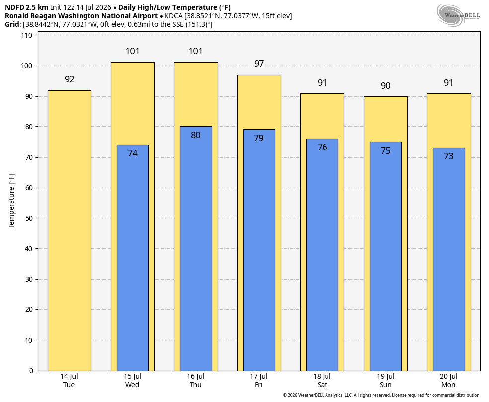
NWS forecast for DC through Monday. (weatherbell.com)
Also consider:
Eleven days at or above 95 degrees already matches the full-season average.
With 25 days at or above 90, this week's heat should push the total past 30 by late week. The seasonal average is about 40, and 90-degree days often continue well into September.
Summer's average temperature of 79.5 degrees through Monday is tied for the fifth warmest on record to this point.
It's shaping up to be one of the hottest summers in recent memory. And with forecasts increasingly pointing to a strong El Niño this winter, it's worth noting that the following summer is often the one that brings the most relentless heat.
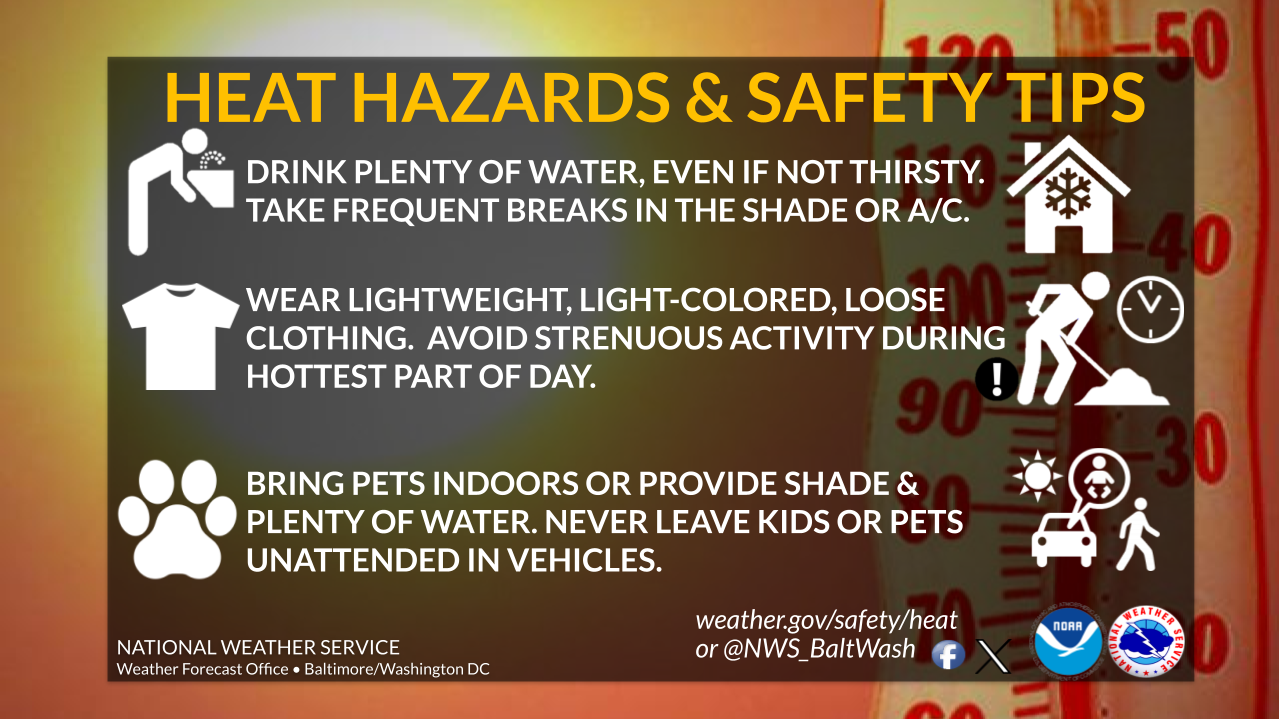
The National Weather Service expects heat index values – how hot it will feel from the combination of heat and humidity – to reach 105 in the heat advisory area.
"Drink plenty of fluids, stay in an air-conditioned room, stay out of the sun, and check up on relatives and neighbors," the Weather Service said.
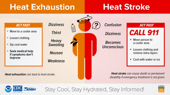
Extreme heat kills more people in the United States than any other weather hazard, according to Weather Service data. Here are important safety tips to get through this week's heat wave...
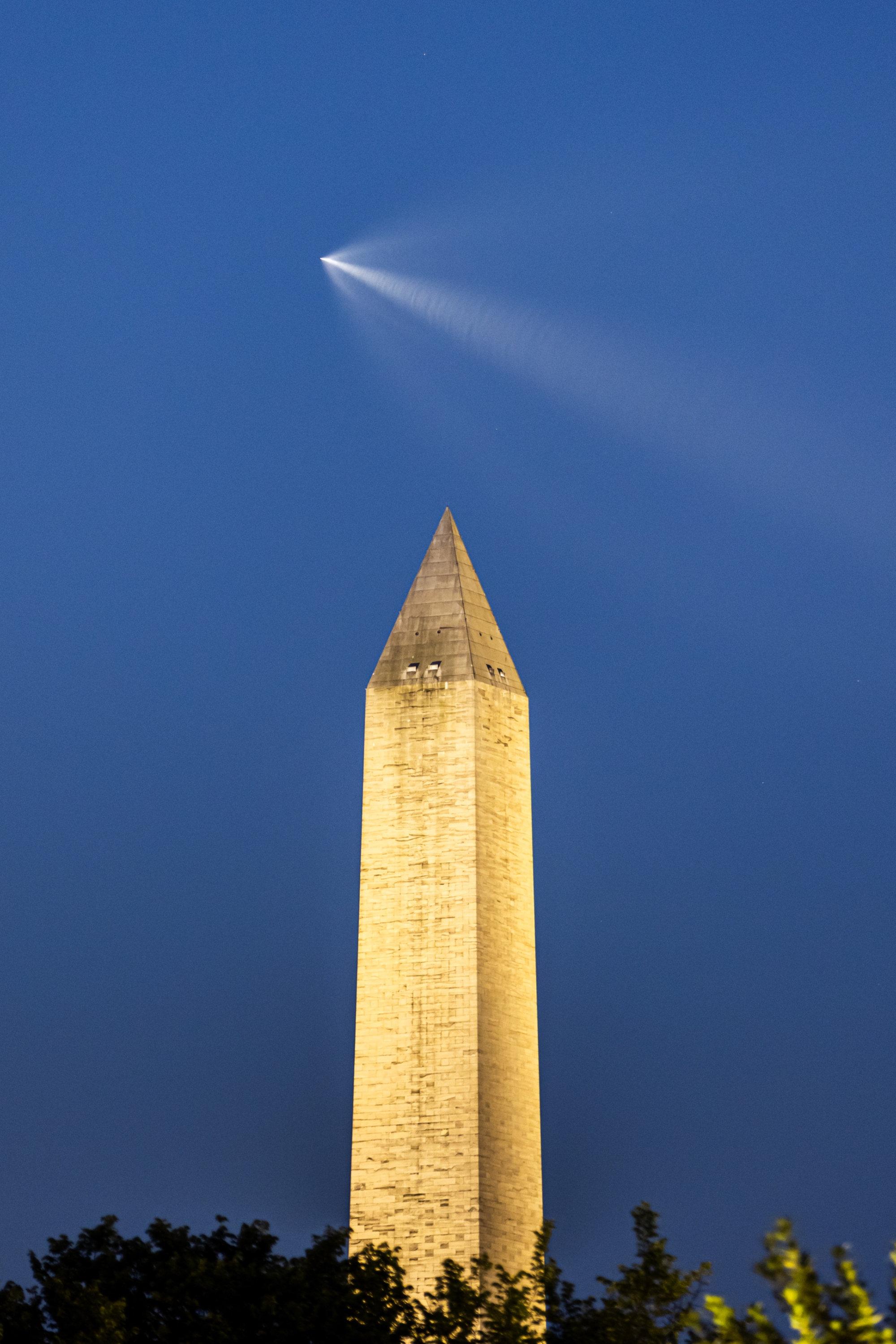
The launch occurred at 5:10 a.m. Tuesday and was visible throughout the Mid-Atlantic thanks to clear skies. As the rocket climbed higher, its sunlit exhaust plume created the appearance of a glowing "space jellyfish" against the still-dark sky.
Phoot of SpaceX Falcon 9 soaring over the Washington Monument Tuesday morning. (Austin DeSisto)
"This occurs when a rocket and its expanding exhaust plumes are illuminated by the sun while observers remain in local darkness," explained the X account Space Jellyfish Alerts, which tracks launches capable of producing the phenomenon.
Because the rocket reached high altitudes while the sun was still below the horizon in the Mid-Atlantic, it was visible across a wide swath of the eastern United States.
Here are some photos and videos of the spectacle shared by Capital Weather readers:
Olney, MD - This morning’s video captures a SpaceX Falcon 9 carrying Starlink satellites climbing into low Earth orbit. The rocket’s high-altitude exhaust plume was illuminated by the rising Sun creating the brilliant streak across the predawn sky. #MdWx#Wx@capitalweather… pic.twitter.com/XKgnw9EdKN