


Sticky, steamy air has returned to the DC region, setting the stage for the possibility of strong to severe storms late this afternoon and especially this evening.
Storms that develop could produce damaging winds, hail, heavy rain, and frequent lightning. There is also an outside chance of an isolated tornado with the most intense storms. Peak wind gusts could reach 60 to 70 mph, toppling trees and causing power outages.
Storms will probably be most numerous along and especially east of the Interstate 95 corridor toward the Chesapeake Bay and Eastern Shore. Coverage may be more limited to the west, but everyone in the region should stay alert and remain flexible with outdoor plans.
The most likely timing is from 5 to 11 p.m. region-wide, but more like 6 to 10 p.m. around the Beltway (earlier to the west and later to the east). Keep in mind that these windows are only approximate and could shift.
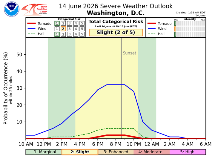
The trigger for the storms is an approaching cold front and a zone of low pressure ahead of it. The National Weather Service has placed the area under a Level 2 out of 5 risk for severe storms.
The storm environment "will support several organized clusters capable of scattered damaging wind gusts, and some locally higher concentrations of wind damage will be possible with any longer-lived clusters that evolve," the Weather Service writes.
Computer models vary in how widespread they forecast the storms to be. Some show only scattered development, while others indicate broader coverage, especially across the eastern half of the region.
In other words, some communities may see little or no storm activity, while others could be hit hard.
We'll post updates if a severe thunderstorm watch is issued and as storms begin to develop.


