



As summers go, this one hasn't been especially humid. Sure, we've had our share of muggy weather, but it has usually lasted only a few days before drier air swept in to provide relief.
That pattern is about to change.
An unusually intense surge of tropical moisture is set to arrive Tuesday night and may linger for more than a week. Atmospheric moisture levels will frequently run about 50 percent above normal for this time of year. Not until a cold front arrives on Wednesday or Thursday next week is the deep plume of tropical air expected to finally be pushed offshore.
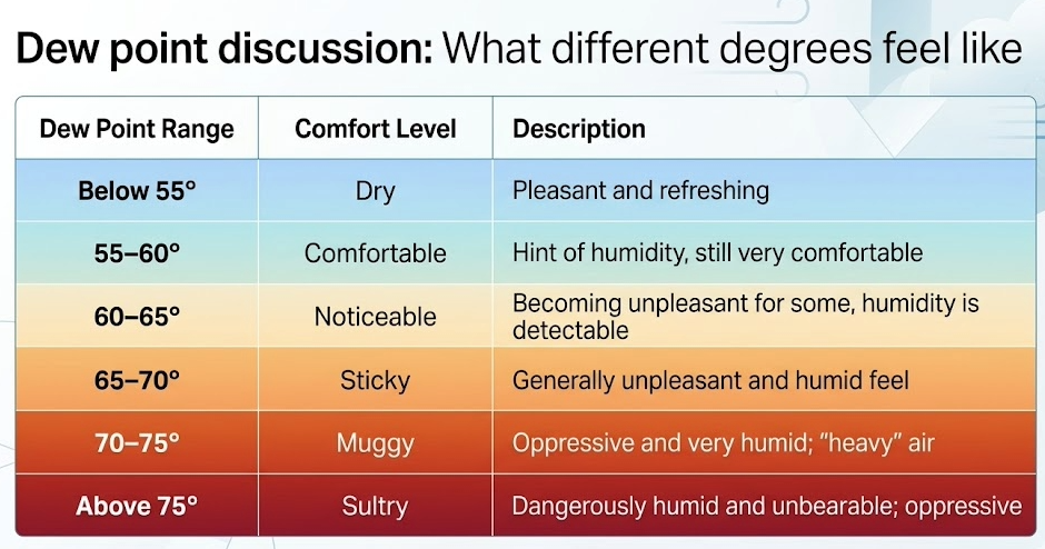
That means day after day of dew points well into the 70s. As a reminder, whenever the dew point — a measure of humidity — rises above 70 degrees, it feels oppressive. Above 75, many people find it downright unbearable. Dew points of 75 are possible at times during this prolonged humid stretch.
Read more: Why we use dew point instead of relative humidity
A humidity wave will hit the Northeast and Mid-Atlantic starting Wednesday, with very high to extreme humidity levels lasting for around a week.
— Ben Noll (@BenNollWeather) August 3, 2026
The Bermuda high pressure system will hug the East Coast and drag tropical air from the Caribbean northward into the region. pic.twitter.com/o7syJxk6CY
The high humidity will also make it feel 10 or so degrees hotter than the actual air temperature. Highs should average around 90, producing afternoon heat indexes near 100 on many days.
The hottest weather may arrive Monday and Tuesday of next week, when highs could climb into the low to mid-90s and heat indexes exceed 100.
The tropical air will also provide fuel for scattered showers and thunderstorms each day, some of which could become heavy or strong. The high moisture levels will increase the potential for localized flooding.
This extended humid spell will be driven by a strengthening area of high pressure off the Southeast coast. Known as the Bermuda High, its clockwise circulation will continuously funnel tropical air northward until the cold front late next week finally sweeps it away.


