



Multiple waves of showers and thunderstorms swept through the DC area Sunday, producing widespread rainfall of 1 to 3 inches.
Reagan National Airport, the city's official observing site, recorded 1.74 inches — its rainiest day of 2026. Only Jan. 25 produced more liquid precipitation, when sleet and snow — dubbed "Snowcrete" — yielded the equivalent of 1.99 inches of rain.
While Sunday's rainfall was impressive, it fell well short of the Aug. 2 record 6.14 inches that fell on Aug. 2, 1944
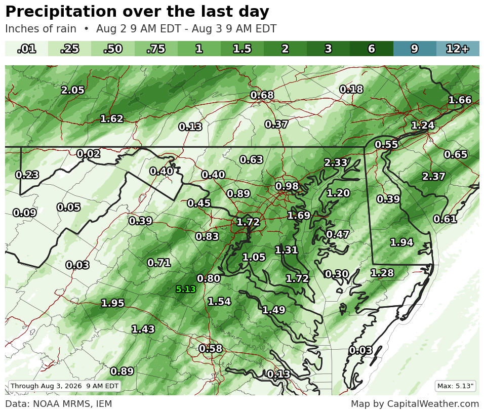
Although 1 to 3 inches was most common, totals ranged from less than a half-inch in parts of the western suburbs to more than 3 inches in isolated locations.
Arlington, which has missed many storms this summer, hit the jackpot, with more than 3 inches in several areas. A broad swath of eastern Fairfax County also received 2 to 3-plus inches. Other corridors of heavy rain, with 2 to 4 inches, stretched across parts of Fauquier, Stafford and Charles counties.
Four Mile Run stream at S. George Mason Dr. in Arlington Sunday after heavy rain. (Steve Taylor)
The downpours prompted a flash flood warning for eastern Fairfax County, Arlington and western portions of DC. Multiple reports of flooding came in between Lorton and Burke, where several roads were temporarily closed because of 2 to 3 feet of standing water.
The rainfall won't erase the region's drought, but it will make a modest dent and gives August a promising start. Eleven of the past 12 months have been drier than normal in DC. With chances for showers and thunderstorms on most days this week, August has an opportunity to begin much wetter than recent months.
Because annual deficits are still 5 to 8 inches across the region, substantially more rain is needed for the drought to end.
A rough forecast
Sunday's deluge was a forecast miss. While forecasts highlighted the potential for showers and thunderstorms — especially during the evening — the heaviest rain developed earlier and proved much more persistent than expected.
Computer models struggled to simulate the extent and duration of the rainfall, particularly before evening. In hindsight, the unusually high atmospheric moisture should probably have prompted a more aggressive rainfall forecast.


