



Showers and thunderstorms dumped 0.5 to more than 2 inches of rain across the DC region Tuesday, helping bring July rainfall totals closer to normal and providing some relief from the drought.
The storms were generally less severe than feared, although there were numerous reports of downed trees from damaging winds east of DC, mainly between southern Prince George's County and St. Mary's County.
The heaviest rain fell in northeast Montgomery and western Howard counties, where some locations picked up 2 to 4 inches. Around 3 inches fell in Columbia, and there was a report of a flooded road in Laytonsville.
DC-area storm event summary for July 21
| Time | Value | Location | Notes |
|---|
At Reagan National Airport, 0.95 inches of rain fell, bringing the month's total to 3.23 inches — right around the normal-to-date value of 3.04 inches.
Some of the heaviest rain fell as an interesting meteorological feature known as a mesoscale convective vortex swept through the area between 9:30 and 10:30 p.m. This counterclockwise swirl, embedded within the larger area of rain, resembled a miniature cyclone and developed from spin generated from a high-altitude disturbance crossing the area.
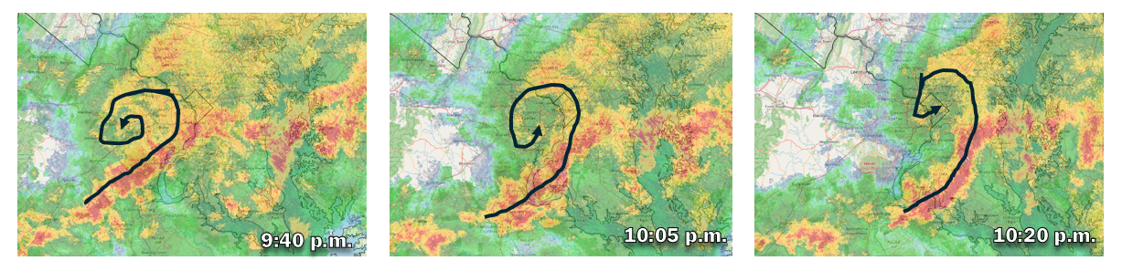
A band of heavy rain wrapped southward from the center of the swirl along what resembled a miniature cold front. Severe thunderstorm warnings were issued for parts of Southern Maryland as it passed, and a wind gust of 66 mph was measured along the Patuxent River near Solomons.
This same feature prompted multiple tornado warnings in West Virginia and western Virginia earlier in the evening. One tornado was confirmed in Pendleton County West Virginia.
Scattered showers and thunderstorms could redevelop this afternoon and evening, mainly near Interstate 95 and to the southeast. Southern Maryland, in particular, could see another round of vigorous storms.


