




The situation: Multiple rounds of showers and storms are possible through this evening, with some capable of producing damaging wind gusts. A severe thunderstorm watch is in effect until 10 p.m. and a flood watch is in effect until 2 a.m. for DC's northern suburbs.
Scroll below live radar and warnings map for breaking updates...
7:00 p.m.: A flood watch is in effect for DC's northern suburbs until 2 a.m. where storms are expected to be most numerous and could track repeatedly over the same areas. "Repeated very heavy rain may result in areas of 3 to 6 inches of rainfall and considerable flash flooding this evening," the National Weather Service wrote.
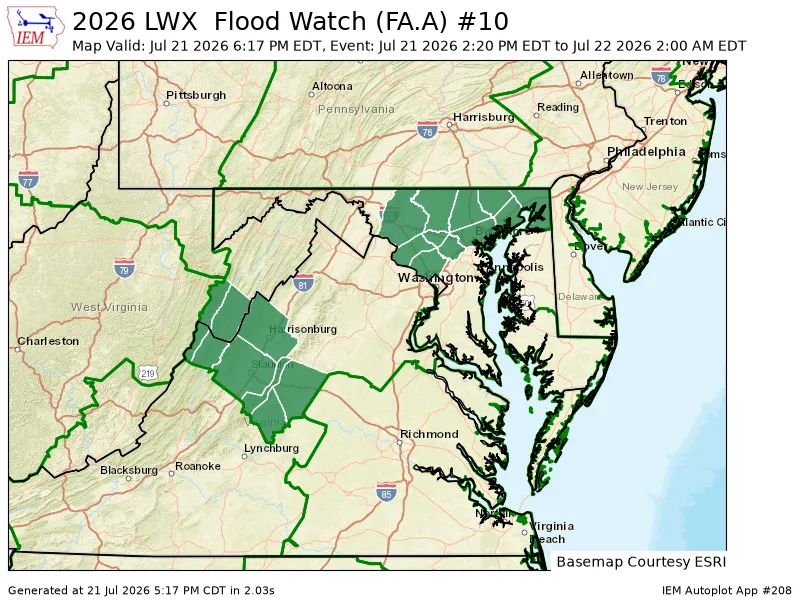
Flash flood warnings have been issued for parts of northeast Montgomery and western Howard counties, as well as around Baltimore, where 1 to 3 inches of rain has fallen and another 1 to 2 inches is possible.
6:30 p.m.: Storms are increasing in areas north and west of the Beltway. An intense storm is located just to the north of Leesburg and is headed east into western Montgomery County. It could contain hail and produce a few damaging wind gusts over the next 30 minutes or so.
Farther east, storms with very heavy rain stretch from northern Montgomery County toward Baltimore, which is under a flood warning until 9:30 p.m.
Meanwhile, storms farther west bear watching. A line of storms west of Interstate 81 has produced an area of rotation that prompted a tornado warning to the southwest of Winchester. These storms will need to be monitored as they head east. They could affect the metro region after sunset.
5:44 p.m.: There are a number of storm damage reports from earlier activity in Prince George's County. High winds toppled trees in District Heights, Upper Marlboro, Clinton, Fort Washington, and Brandywine. About 4,000 customers have lost power in the county, according to PowerOutage.us.
The strongest storms currently stretch from Poolesville to College Park and are lifting north. We'll also need to watch additional severe weather well to the west for later evening.
5:15 p.m.: The biggest storms in the area are passing Annapolis. Additional storms have popped up from near Wolf Trap to McLean and are lifting north toward Rockville.
4:30 p.m.: This first batch of storms is focused southeast of the Beltway, with a new warning until 5 p.m. for parts of PG and Charles County. It could produce damaging wind gusts to 60 mph.
4:10 p.m.: The storm south of the Beltway into southern suburbs became the first local warning of the day. It runs until 4:45 p.m.
Severe Thunderstorm Warning including Waldorf MD, Fort Washington MD and Woodlawn VA until 4:45 PM EDT pic.twitter.com/q8r0k0RI2f
— NWS Baltimore-Washington (@NWS_BaltWash) July 21, 2026
3:55 p.m.: So far, the most problematic storms – producing flash flooding and damaging winds – have been well south toward Richmond or north of the Maryland border in southern Pennsylvania. Some strong storms passing through southern Maryland could have occasional gusty winds while additional showers push through Loudoun County.
2:50 p.m.: The National Weather Service has issued a severe thunderstorm watch until 10 p.m. The agency says damaging wind gusts are the primary risk but that a couple brief tornadoes and instances of large hail are also possible.
Remember that a severe thunderstorm watch means conditions are favorable for severe storms, not a guarantee. But, if a severe thunderstorm warning is issued for your location, it means seek shelter immediately.
A severe thunderstorm watch has been issued for parts of Delaware, District of Columbia, Maryland, North Carolina, Virginia and West Virginia until 10 PM EDT pic.twitter.com/qatuZbJlCk
— NWS Severe Tstorm (@NWSSevereTstorm) July 21, 2026
It's possible that there are at least two rounds of storms, one late this afternoon into the early evening (through 6 p.m.) and another near and after sunset (7 to 11 p.m.).


