


The situation: Thunderstorms are mostly done, although a few isolated rumbles remain possible as areas of rain linger the next few hours.
Scroll below live radar and warnings map for breaking updates...
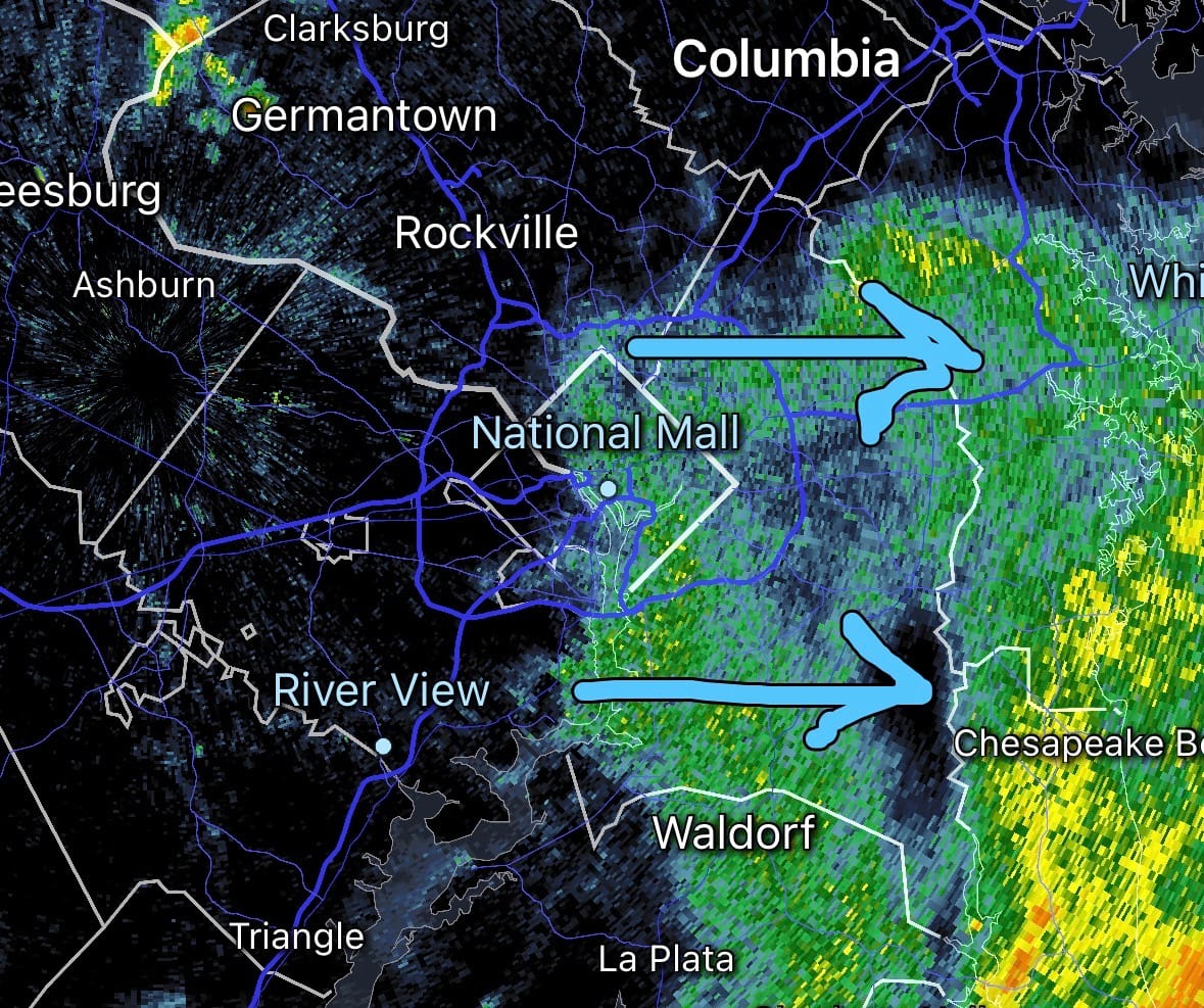
11:55 p.m.: Looking at latest radar loop, some more rain could come through the National Mall during the next hour. There was quite a bit of lightning with these showers when they were farther south. That seems to have calmed down, but can’t rule it out.
11:50pm: Looking at latest radar loop, some more rain could come through the National Mall during the next hour. There was quite a bit of lightning with these showers when they were farther south. That seems to have calmed down, but can’t rule it out. pic.twitter.com/aygoRIShLZ
— Capital Weather (@capitalweather) July 5, 2026
10:30 p.m.: Radar shows rain now moving out of the National Mall.
9:35 p.m.: The severe thunderstorm watch is now canceled for the entire DC region. Light to moderate rain should continue to fall in and around DC for the next hour or so. Add another hour on to that for areas farther east. As rain tapers, winds diminish. The National Mall fireworks show is still scheduled to occur, but now after 11 p.m.
8:55 p.m.: The thunderstorm watch has been canceled in western suburbs and west, and it's pretty likely the risk is done here except perhaps parts of southern Maryland over the next hour. Light to moderate rain, especially near and east of Interstate 95, will unfortunately continue into fireworks shows in a number of locations, but the concern over dangerous weather is low.
8:25 p.m.: Steadier rain with some embedded thunder is crossing the southwestern Beltway in the near term, which puts it increasingly into downtown DC over the next half hour. This area of light to moderate rain could last an hour or so once it starts, but it should continue to diminish in intensity this evening.
7:25 p.m.: Storms are currently skirting around DC. There is no warning currently in effect for DC despite the evacuation of the National Mall. There are storms approaching from the southwest that could come through over the next couple of hours with lightning and strong winds, although there is a chance they weaken on approach.
WEATHER EVACUTATION ALERT FOR FIREWORKS VISITORS
— National Mall NPS (@NationalMallNPS) July 4, 2026
Due to the severe weather in the area, we are asking visitors to seek shelter. Please follow the directions of the Park Rangers, law enforcement personnel, or other event staff.
Stay alert, stay safe, and enjoy July 4…
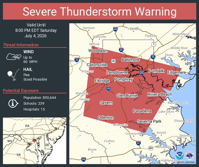
7:05 p.m.: Watch out around Baltimore, where a severe thunderstorm warning is now in effect until 8 p.m. That storm is approaching Baltimore from the south, on track to arrive around 7:30 p.m. Damaging 60 mph wind gusts possible.
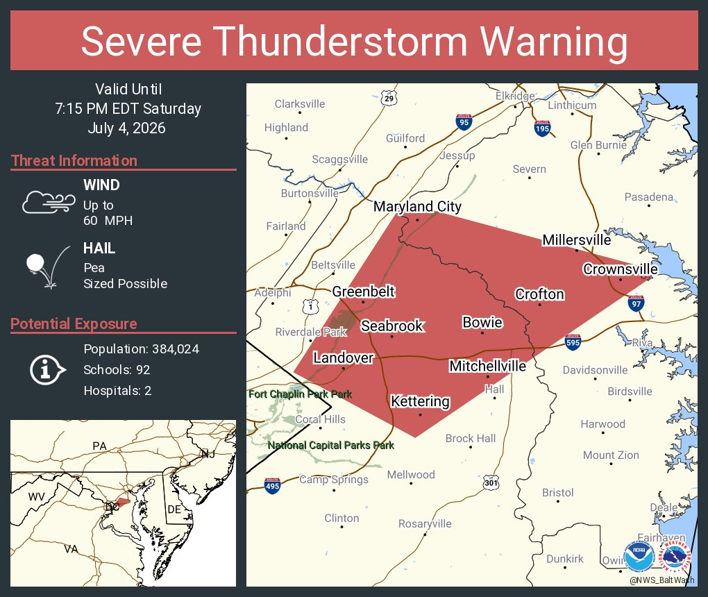
6:55 p.m.: Northern Prince George's and northwest Anne Arundel counties now under a severe thunderstorm warning until 7:15 p.m. Locations including Bowie, Glenn Dale, and Crofton are in the path of the storm that could produce damaging 60 mph wind gusts.
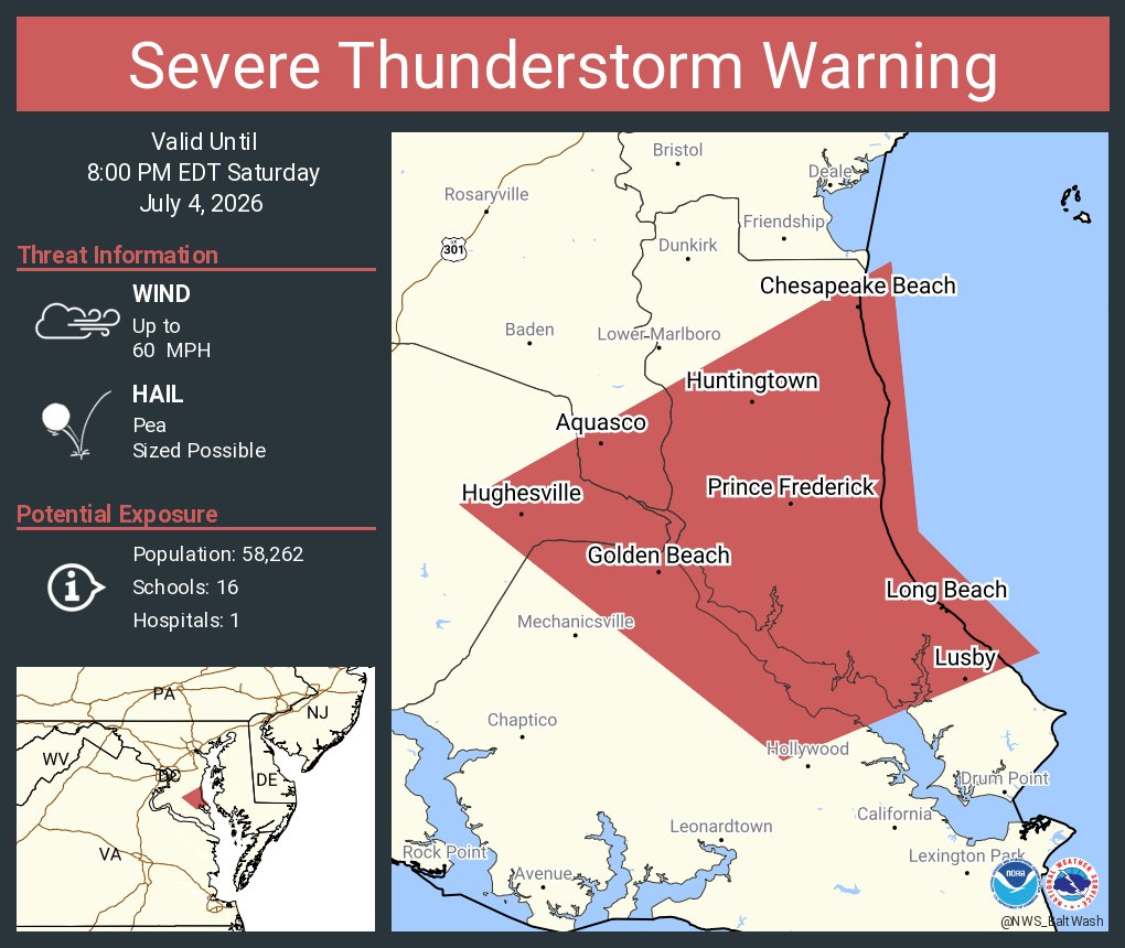
A new severe thunderstorm warning is also up for much of St. Mary's County until 8 p.m., including Prince Frederick and Huntingtown. Damaging 60 mph wind gusts possible.
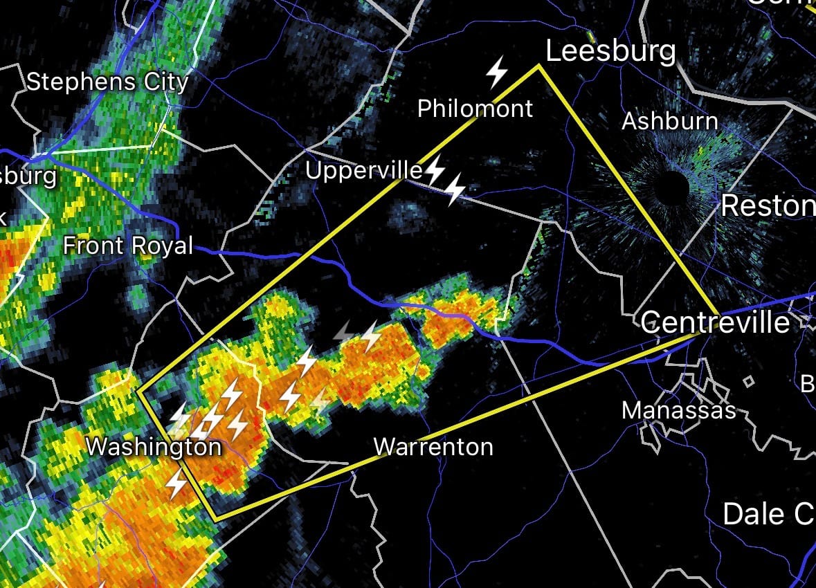
6:50 p.m.: Parts of northern Fauquier, northern Prince William, and southern Loudoun counties are under a severe thunderstorm warning until 7:30 p.m., for a storm that has potential for damaging 60 mph wind gusts and quarter-size hail. The Plains, Middleburg, and Haymarket are included in the warning. Centreville is near the eastern edge of the warning.
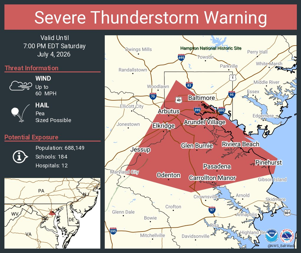
6:40 p.m.: A storm cell in northern Anne Arundel County near Glen Burnie has earned a severe thunderstorm warning until 7 p.m., with damaging wind gusts near 60 mph possible. The warning extends northward to Baltimore.
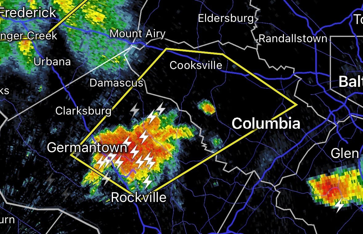
6:30 p.m.: Severe thunderstorm warning for northeast Montgomery and much of Howard counties until 7:15 p.m. The storm, which could spawn damaging wind gusts near 60 mph, is now moving northeast from the Germantown and Gaithersburg area into Olney, Brookeville, and Laytonsville with strong winds, heavy rain, and lightning. Columbia and Ellicott City are along the eastern edge of the warning.
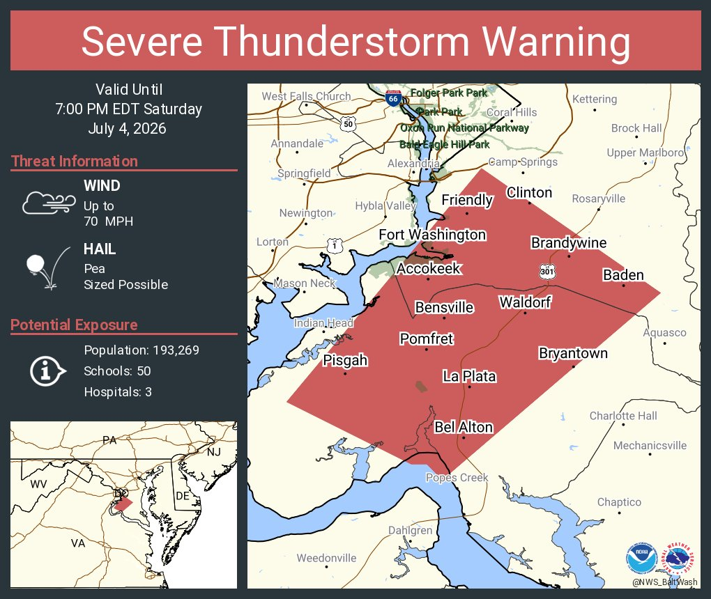
Another warning, for damaging wind gusts up to 70 mph, is in effect for much of Charles and far southern Prince George's counties until 7 p.m., including La Plata, Waldorf, and Brandywine.
6:20 p.m.: Radar above shows some storms now popping a bit closer to the Beltway – to the north in central Montgomery County, and to the south in western Charles and southwestern Prince George's counties.
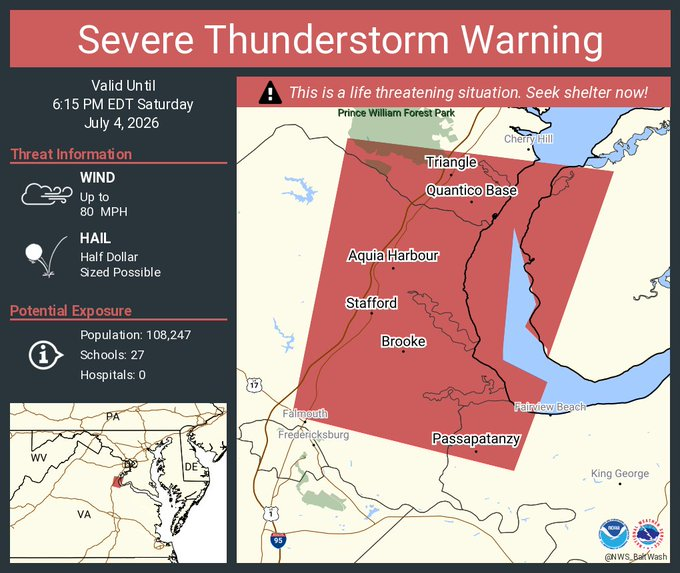
5:45 p.m.: A "destructive" severe thunderstorm warning, the most serious, is in effect until 6:15 p.m. for much of eastern Stafford and western Charles counties, where 80 mph gusts and hail the size of a half dollar are possible. The warning includes Stafford, Aquia Harbour, Quantico, and Triangle. Dumfries is right along the northern edge of the warning.
Meanwhile, a severe thunderstorm with potential for damaging wind gusts near 60 mph is now moving into Frederick, Md., from the west. The severe thunderstorm warning for Frederick continues until 6:45 p.m.
The cell in southern Prince William County as quickly diminished.
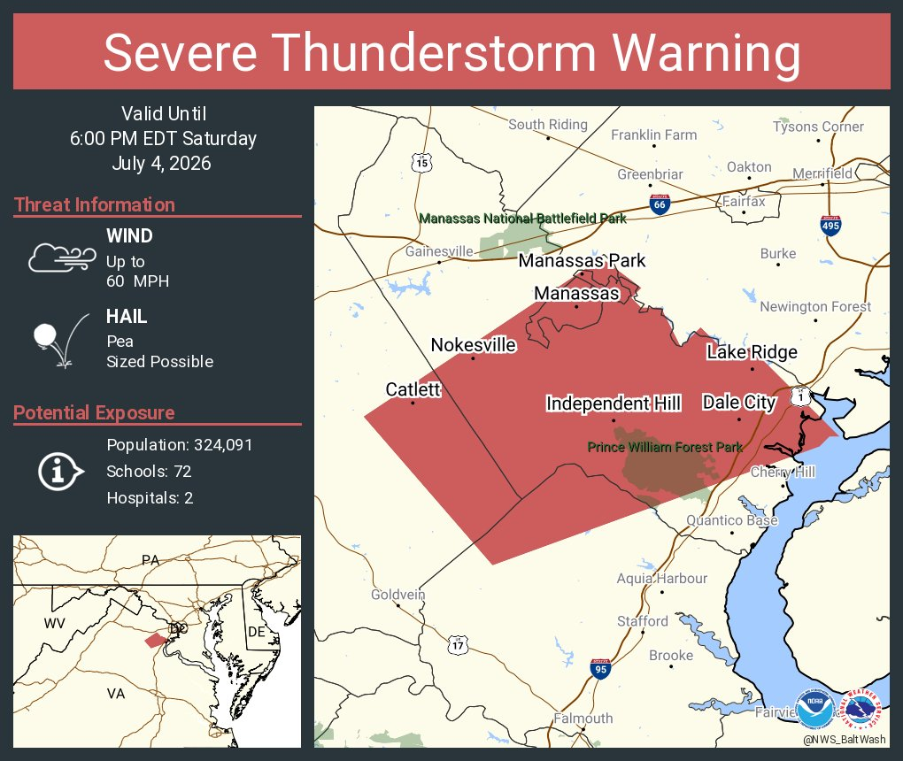
5:15 p.m.: A storm cell in southwestern Prince William County and heading northeast has prompted a severe thunderstorm warning until 6 p.m. for much of southern Prince William County. The warning includes Dale City and Manassas, although the worst may pass south Manassas. Damaging wind gusts of 60 mph possible.
5:05 p.m.: Scattered storms are starting to approach the DC region from the west and south, including a severe thunderstorm warning for the Fredericksburg area and another in northwest Fauquier County.
2:50 p.m.: Any severe storms that develop in the severe thunderstorm watch area this afternoon into evening threaten scattered damaging winds near to over 60 mph, isolated gusts up to 75 mph, and isolated large hail to 1 inch in diameter, the National Weather Service said.
A severe thunderstorm watch means the ingredients are in place for storms that develop to turn severe. A warning will be issued if a severe thunderstorm actually develops and approaches your location.


