




Amid blinding curtains of rain and crashing trees, Ari Neugeboren couldn't believe the intensity of the tempest sweeping through northwest DC on Tuesday evening.
He estimated wind gusts of around 80 mph in his Van Ness neighborhood. "This is most certainly my most extreme DC weather moment in memory — with the derecho [of June 29, 2012] being hazier, but this certainly on par with it," he said in an email.
The storm that rocked parts of northwest DC was one of several that toppled trees and power lines across the region Tuesday as a strong cold front barreled through. More than 30,000 customers lost power, and the National Weather Service received dozens of reports of downed trees from Fredericksburg to Baltimore.
Neugeboren recorded video as the storm reached its peak and said it raged at full fury for about 90 seconds. His footage resembles scenes from a hurricane:
Neugeboren wasn't alone in comparing the storm's ferocity to the infamous June 29, 2012, derecho.
Capital Weather X user Heidi Gil, in nearby McLean Gardens, called it the worst storm there since the derecho. She shared photos of large trees toppled, some crushing parked cars:
McLean Gardens took a beating in that storm. Maybe a microburst?@capitalweather pic.twitter.com/01zIH0y23d
— Helder Gil (@hgil) July 28, 2026
ABC7 news reporter Scott Thuman shared nearby video of "insane" wind and rain which he said blew two chairs off of a building roof.
Significant tree damage extended into neighboring Cathedral Heights, where at least one utility line toppled:
Major storm damage in the Cathedral Heights area of Washington DC today. @capitalweather pic.twitter.com/Akpf1WftDo
— Andrew Leyden (@PenguinSix) July 29, 2026
Just three miles to the east, not far from Catholic University, the winds knocked over the roof of a gas station at Georgia Avenue and Farragut Sreet NW:
This gas station at Georgia Avenue and Farragut Street NW didn’t fare too well during the storm. pic.twitter.com/ekb1wOBb54
— Martin Austermuhle (@maustermuhle) July 28, 2026
The Weather Service estimated that peak gusts in microburst winds reached 60 to 70 mph in northwest DC.
Although Tuesday's storm drew comparisons to the 2012 derecho in parts of northwest DC, the two events differed in scale. The fast-moving derecho unleashed widespread 60- to 80-mph winds across much of the DC area and cut power to around 1 million customers. Tuesday's most intense winds were far more localized.
A rager in NW DC @capitalweather.com
— Ian (@ianlivingston.bsky.social) July 28, 2026 at 6:23 PM
[image or embed]
Damage in DC probably from microbursts, not tornado
The ferocity of the winds raised the question of whether a tornado had swept through northwest DC.
Our analysis of radar data indicates the damage was most likely caused by one or more microbursts — intense downdrafts that descend from thunderstorms, slam into the ground and spread outward. They can easily produce wind gusts as strong as, or even stronger than, those in weaker tornadoes.
The radar data we reviewed showed no clear signs of rotation. Instead, it exhibited a divergent wind pattern characteristic of a microburst.
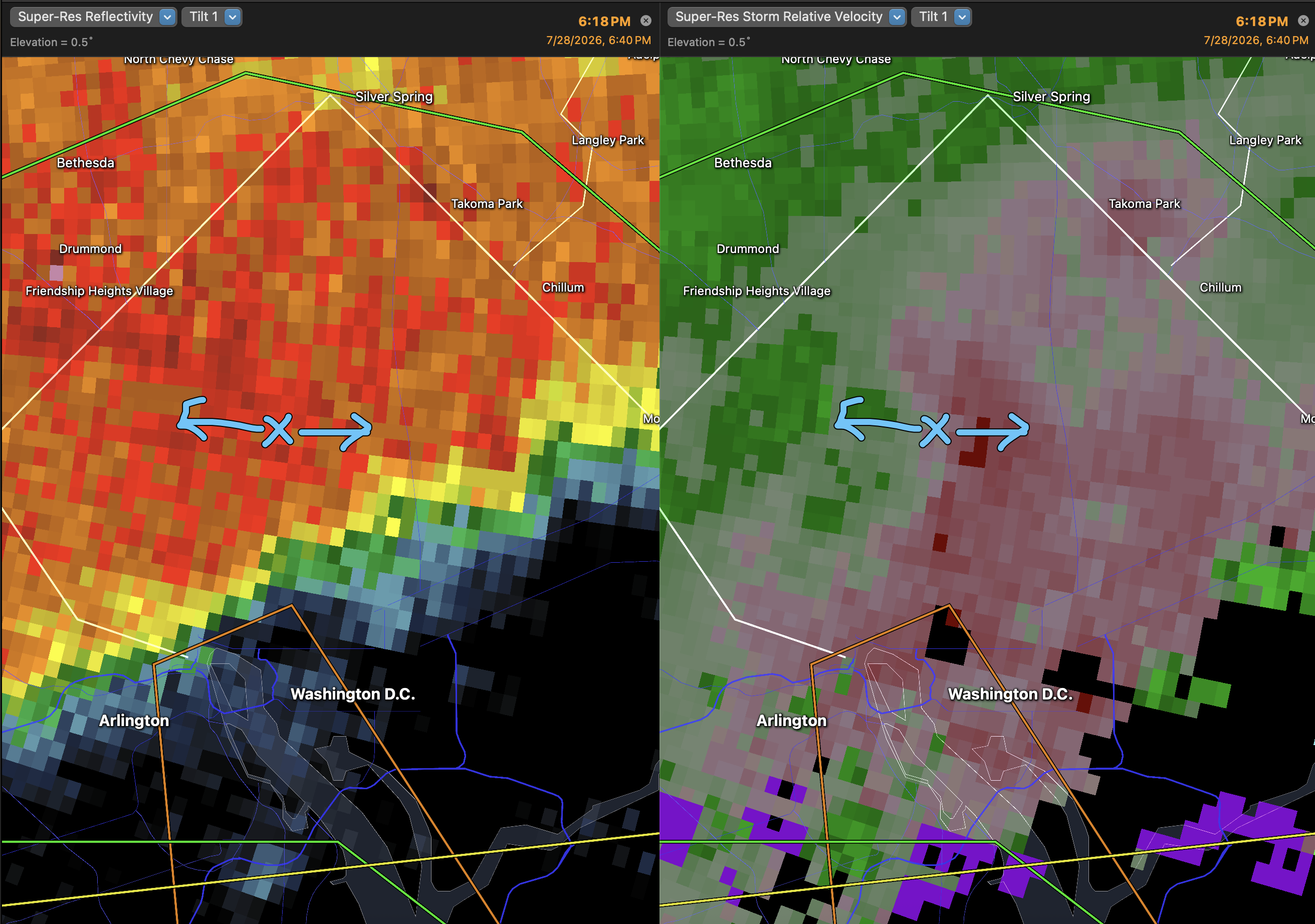
Microbursts occurred elsewhere in the region
Northwest DC was not the only area subjected to such fierce winds and treefalls. Numerous trees came down, some onto homes, in Montgomery County. Gaithersburg and Brookeville were particularly hard hit.
Brookeville, MD - Numerous trees are down in the area due to the strong winds, this one off of Brighton Dam Rd. #MdWx #Wx @capitalweather @MeteoMdWX @JustinWeather @WashingtonianWx pic.twitter.com/oX5bKQFMPY
— MyDrone.Pro (@MyDronePro) July 29, 2026
The map below shows the storm warnings that were issued by the Weather Service as well as the location of wind damage reports and flooding.
DC-area storm event summary for July 28
| Time | Value | Location | Notes |
|---|
Most of the reports of flooding occurred around Baltimore where up to 2 to 4 inches of rain fell in a short time.
Tornadoes may have occurred in the area
Additional areas of tree damage coincided with areas that were under tornado warnings, most notably in Anne Arundel County. The Weather Service received reports of large numbers of downed trees in Severna Park and Pasadena. It said it plans to survey the damage in this area on Wednesday to determine if a tornado touched down.
Another suspicious area of tree damage occurred near Laurel, where radar exhibited storm rotation.
Confirmed tornadoes were reported in broader region, including in Trappe, on Maryland's Eastern Shore, which is 8 miles south of Easton.
Storm Coverage Video (Talbot County)
— Eastern Shore Undercover ® (@ShoreUndercover) July 28, 2026
📍 Trappe, MD
⏰ Tuesday, July 28, 2026 at 6:45 PM
A few of our followers were kind enough to send in these clips from tonight's storm in Trappe, Maryland. Pretty scary looking at the way it all came together! Everyone please be careful out… pic.twitter.com/GMQm08j9lH
To the south, footage of a waterspout was captured near Newport News, Virginia.


