




This article is currently available as a public preview during our launch period. In the future, it will be available exclusively to Friends and Founders members. Become a member to support our work and enjoy unlimited access to our premium content.
After an unusually warm April and record heat in mid-May, spring has taken control with 60s and 70s more common than 80s. But summer seldom fails to deliver in swampy DC, notorious for its punishing heat and humidity.
Compared with a typical DC summer, we expect the upcoming one to be fairly typical, featuring its share of sweltering days and warm, muggy nights. Although brief cooler spells may offer fleeting relief, it will probably end up hotter than last summer which featured the coolest August in 25 years.
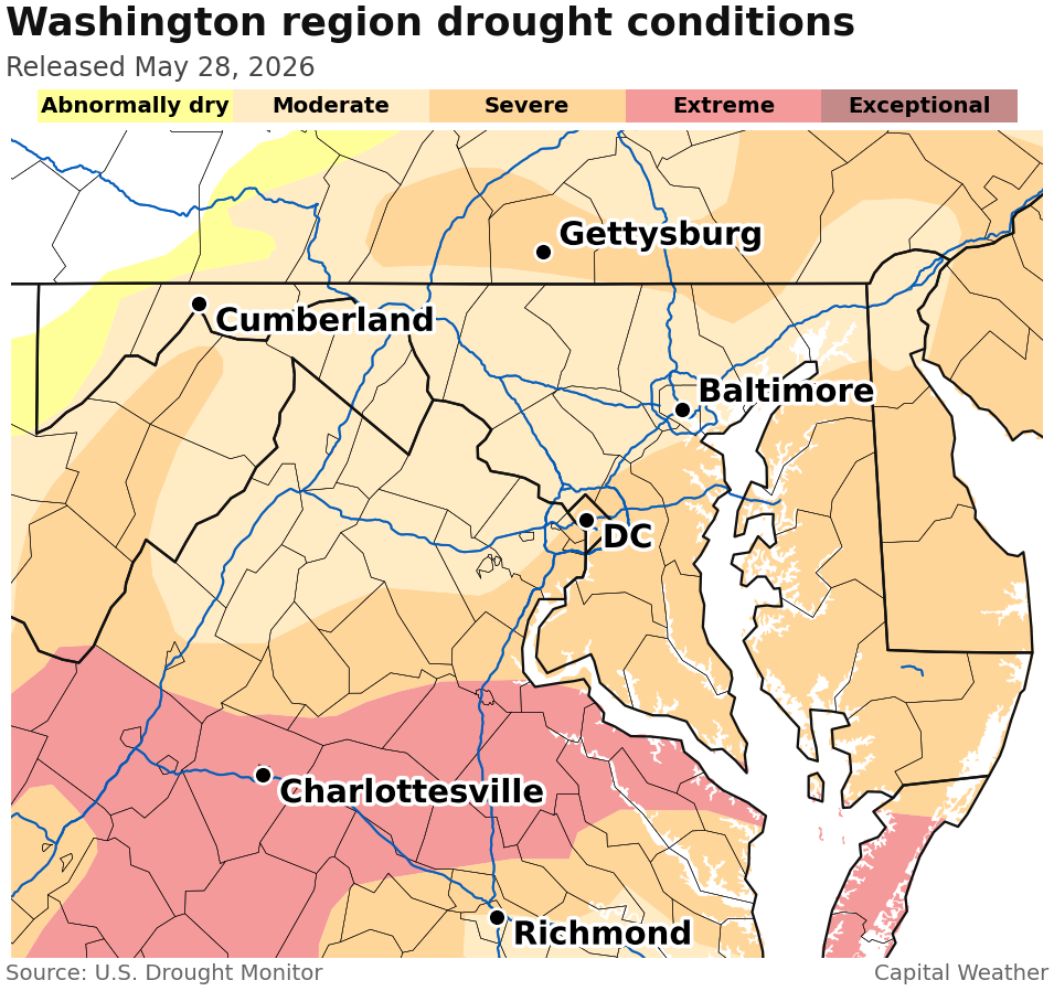
The question on many people's minds is whether we'll experience meaningful drought relief. Ten of the last eleven months have been drier than normal.
We don't yet see a strong signal for drought-busting rains, but neither do we see strong indications that the dryness will worsen. DC's summer rainfall is strongly tied to whether we experience tropical deluges. A single tropical storm can produce enough rain to seriously dent a long-standing drought. Whether such a tropical system will affect the area generally cannot be reliably predicted more than a week ahead of time.
Taken together, the signals suggest this summer will land on the warm side of normal. That's in keeping with many of the summers since 2005 as well as long-term trends.
10 hottest summers in D.C.
Year | Average temperature |
|---|---|
2010 | 81.3 |
2011 | 81.1 |
2024 | 80.9 |
2016 | 80.6 |
2012 | 80.4 |
2020 | 80.2 |
1980 | 80.0 |
2015 | 79.6 |
2019 | 79.5 |
2021 | 79.5 |
Nine of D.C.'s 10 hottest summers have occurred since 2010, reflecting the influence of human-caused climate change. We don't think this summer will be scorching enough to make the top 10, but it could land in the top 25.
Our outlook — provided in detail below – covers June 1 through Aug. 31, or the period known as meteorological summer.
Summer outlook by the numbers
June through August average temperature: Normal to 1 degree above the average from 1991 to 2020. Last summer was 0.5 degrees below average.
Temperatures compared to average by month:
- June: Normal to 1 degree above average. Last June was 0.3 degrees above average.
- July: Normal to 1 degree above average. Last July was 1.4 degrees above average.
- August: 1 degree above average. Last August was 3.6 degrees below average.
Number of 90-degree days (June-August): 35, compared with an average of 34. Last summer, there were 34 90-degree days between June 1 and August 31.
Note that an additional six days of 90-degree temps occur on average outside June to August. This year, we already have five.
Longest streak of 90-degree days: 8 to 10 days. Last summer, the longest streak was seven days, July 25 to 31.
Number of 100-degree days: 1 to 2 days. Last summer, there were 0.
Precipitation: Slightly below average. Last summer, 9.22 inches fell, compared with the norm of 11.78 inches.
Answers to questions you may have
How does your outlook compare to others?
Our outlook is consistent with National Weather Service's June-August projections. It leans toward above normal temperatures and near normal precipitation in our area.
NBC4 chief meteorologist Doug Kammerer summer outlook calls for the heat not to be extreme but "plenty of humidity." Kammerer expects a lot of rain, easing or ending the drought.
My SUMMER FORECAST for heat. Take a look! A Strong El Nino typically means we do NOT see intense heat, but we do see more humidity and rainfall potential. All in all, it should be a pretty good summer. pic.twitter.com/D2OBVyd412
— Doug Kammerer (@dougkammerer) May 18, 2026
How reliable do you consider this outlook?
Although advances have been made in seasonal forecasting, there is still uncertainty and limited skill. This is a medium confidence forecast.
Will the El Nino mean for the summer?
Much is being made of forecasts for a potentially strong or "super" El Niño by the fall. Although El Niños are associated with stormy winters in the eastern United States, they have not historically exerted a major influence over summer weather patterns.
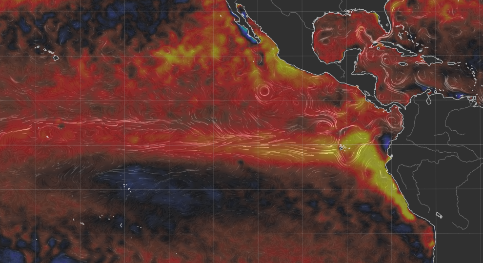
One well-known impact of El Niños is reduced Atlantic hurricane activity. If that's the case this summer, it would reduce the chance of beneficial rain that could curb the drought, from the remnants of tropical systems.
How accurate was your summer outlook last year?
Last summer's outlook was not our best. We predicted a summer that would rank among the 10 hottest on record and it ended up being slightly cooler than normal. Our forecast for the previous summer (in 2024) was much more accurate.
Do you take climate change into account in your summer outlooks?
Yes. Our “new normal” summer is hotter than it was a few decades ago. A summer that’s only somewhat warmer than normal in today’s climate would have been historically hot a few decades ago.
Compared to temperatures in the late 1800s, when official weather records began, the changes are stark:
- We now average about 40 90-degree days per year; 150 years ago that number was closer to 25.
- We now average multiple summer nights with low temperatures at or above 80 degrees. These nights were almost unheard of in the late 1800s.
Aren’t weather forecasts only reliable out to about eight to 10 days?
There is little skill in predicting specific conditions, such as the exact temperature and amount of rain for a given day, more than eight to 10 days into the future. However, seasonal forecasting advances allow us to make educated guesses on overall weather tendencies, such as how temperatures and precipitation will compare with the average over the period of a month or several months. Because of the uncertainty involved, we give ranges and attempt to be transparent in communicating outlook limitations.
Methodology
We considered several factors in preparing this outlook. It should be noted that any one factor doesn’t necessarily correlate with a particular kind of summer (e.g., warm, cool, dry or wet).
As noted, forecasters expect a rapidly strengthening El Niño event over the coming months. Although El Niño doesn't exert a strong direct influence on summer weather patterns, we considered past summers in which this climate pattern was forming to inform this outlook.
We also took into account the persistently negative phase of the Pacific Decadal Oscillation — which has a loose connection with hot summers in the eastern United States.
Finally, we took into account predecessor weather patterns from the spring. These inputs informed the identification of analogs, or years with similar weather patterns, that we used in putting together our outlook.
The summer of 2002 emerged as one strong analog. The weather during that summer, which was somewhat hot and on the dry side, was given some consideration in our projections.
We should note that D.C.'s persistent and seemingly impenetrable urban heat island makes it difficult to experience a much cooler-than-normal summer, regardless of the broader weather pattern.


