


The situation: A line of strong storms with damaging winds tracked west to east across the DC region Thursday evening. There were numerous reports of downed trees and power outages, with some gusts up to 60 mph reported.
9:30 p.m. update: The storms have now moved east into the Chesapeake Bay and the severe threat is over for the DC region. Leftover showers could linger in some spots until about 11 p.m.
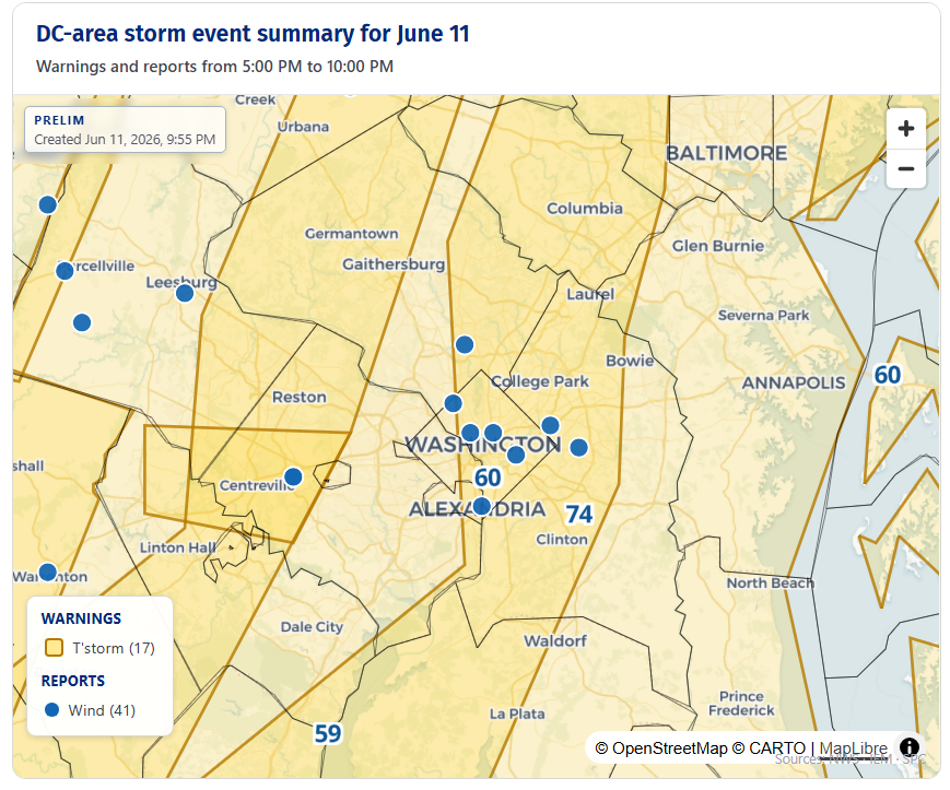
The storms produced gusts up to 60 mph at Reagan National Airport, downing trees and power lines in DC, Alexandria, and in southern Montgomery, Fairfax, Fauquier, and Loudoun counties. A gust of 74 mph was clocked at Joint Base Andrews in Prince George's County.
Power outages as of about 9:30 p.m. were reported at about 25,000 in Fairfax County; 10,200 in Fauquier County; 10,000 in Prince George's County; 6,300 in Loudoun County; 4,500 in DC; 3,000 in Charles County; 2,500 in Stafford County; and 2,300 in Montgomery County.
The storms also produced dramatic photos of menacing skies.
Previous updates
8:50 p.m. update: Power outages are being reported across parts of the region, including 7,900 customers without power in the City of Alexandria and 1,249 in the Town of Warrenton, with a "much larger number of customers without power in Fauquier County," according to emergency management officials.
8:30 p.m. update: Severe thunderstorm warnings now stretch from around DC and I-95 east to the Chesapeake Bay as this line of storms with a history of damaging winds advances through the eastern half of the region. Try to delay travel while these storms pass through your area.
These storms have a history of wind gusts up to 60 mph, including at Reagan National Airport. Trees have been reported down in DC, Alexandria, and in Prince William, Loudoun, and Montgomery counties.
8 p.m. update: As this line of strong storms continues to advance east, the Beltway and I-95 corridor are now under a severe thunderstorm warning until 8:30 p.m. This new warning area stretches from Fredericksburg at the south end to northern Carroll and Baltimore counties on the north end. Wind gusts up to about 60 mph could bring down trees and large branches. Try to delay travel while these storms pass through your area.
7:50 p.m. update: The National Weather Service has issued a targeted severe thunderstorm warning until 8 p.m. stretching from northern Prince William County eastward into far southern Loudoun County and western Fairfax County due to potential for destructive 70 mph wind gusts. This includes Centreville, Fairfax, Vienna, Oakton, Chantilly, and Manassas.
Severe Thunderstorm Warning including Centreville VA, Oakton VA and Fair Oaks VA until 8:00 PM EDT. This storm will contain wind gusts to 70 MPH! pic.twitter.com/y46LQZAgKj
— NWS Baltimore-Washington (@NWS_BaltWash) June 11, 2026
7:25 p.m. update: The line of strong to severe storms, still mostly a solid one, is now moving east through Fauquier, Loudoun, and Frederick counties, where severe thunderstorm warnings are in effect due to possible 60 mph wind gusts. Warnings also extend east into portions of Montgomery, Fairfax, and Prince William counties.
If the line holds together, it should track east across the immediate Beltway area around 8 to 9:15 p.m. As long as the storms continue to maintain their strength, try to delay travel while they pass through your area.


