



The situation: Storms have exited the DC region and will push through Virginia's Northern Neck and Maryland's Eastern Shore through 8 p.m. Severe thunderstorm and flood watches have been discontinued for the DC metro area.
Scroll below live radar and warnings map for breaking updates...
7:00 p.m.: As storms have exited the metro area, the National Weather Service has discontinued the severe thunderstorm and flood watches previously in effect. For the forecast for the rest of tonight through the weekend, see our full forecast.
6:35 p.m.: Strong storms are lined up from around Easton, Maryland southwest to near Fredericksburg, Virginia. Over the next hour, they'll push southeastward toward Cambridge and Lexington Park in Maryland and Virginia's Northern Neck. These areas should expect very heavy rain, lightning and the possibility of a few damaging wind gusts through around 8 p.m.
To the north and west, including the Beltway area, the severe weather threat is over and just a few showers linger.
6:30 p.m.: The tornado warning in effect for parts of Southern Maryland has been discontinued.
6:20 p.m.: A tornado warning is in effect for western St. Mary's County and south central Charles County until 6:30 p.m. A confirmed waterspout was observed over the Tidal Potomac, just offshore near Wicomico River, moving east at 30 mph. Rock Point, Issue, and Cobb Island are in the path.
6:18 pm: Severe weather threat focused on southern MD next hour or so. Magenta polygon is for a confirmed waterspout moving ashore as a tornado.
— Capital Weather (@capitalweather) July 9, 2026
Intensity diminishing in the immediate area.
Updates at https://t.co/Jm2qthUpLG pic.twitter.com/J13zka2XN1
5:25 p.m.: Storms stretch from southern DC, through Alexandria, and south along the Potomac River to near Indian Head and Quantico. The line continues to march east, at sub-severe levels in the immediate area. Reagan National picked up about 0.15 inches with the line so far but rain continues to fall there. Dulles Airport was past 1 inch.
Outside of southern Md., the severe threat is diminished. A storm warning is in place south of La Plata through 5:45 p.m.
@capitalweather a tree branch just impaled my hot tub cover in Stafford, Va pic.twitter.com/mTuXuztpxJ
— Becky McNeil (@RedRaiderBecky) July 9, 2026
4:40 p.m.: Strong storms are now reaching the western Beltway. While no storms are warned in the immediate area, gusty winds, dangerous lightning and torrential rainfall are likely with this line as it shifts eastward. The focus is mainly near and south of Interstate 66 and will include DC in the time ahead.
4:00 p.m.: After first focusing on areas north of the Beltway, showers and storms are increasing their coverage across the rest of the region as more of them move in from the west. No warnings for wind or flash flooding are currently in effect despite some pockets of heavy rain and frequent lightning.
3:40 p.m.: The strongest storm in the region currently is in southeast Montgomery County now advancing eastward into northern DC and northern Prince George's County with heavy rain, lightning, and winds gusts up to around 50 mph.
3:25 p.m.: At the moment there are no severe thunderstorm warnings in effect, as there is no indication that any storms are currently producing damaging winds. However, storms with heavy rain and lightning cover much of Montgomery County westward into central Loudoun County and are headed east. More storms are gathering and approaching the entire DC region from the west.
2:47 p.m.: As the storms north of the Beltway advance east, much of central Montgomery County is now under a severe thunderstorm warning until 3:15 p.m. Damaging 60 mph wind gusts are possible for locations including Gaithersburg, Rockville, Germantown, Clarksburg, and Olney.
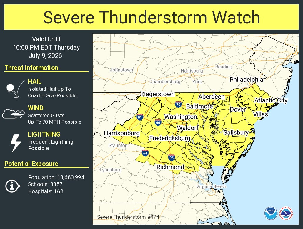
2:45 p.m.: As expected, the National Weather Service has now issued a severe thunderstorm watch for the entire DC region until 10 p.m. and warns of storms that could produce damaging wind gusts up to 70 mph.
2:15 p.m.: A large portion of northern and western Montgomery County, as well as a portion of central Loudoun County, is under a severe thunderstorm warning until 2:45 p.m., due to potential for damaging 60 mph wind gusts and quarter-size hail.


