


An intense, record-challenging heat wave arriving in the DC area Wednesday looks like it will continue through Saturday July 4. Temperatures on the Fourth may be a few degrees below the peak of the heat expected Thursday and Friday, but could still be dangerously hot.
The chance of late-day thunderstorms on the Fourth may be higher than the previous days, but there won't be much confidence in that until later this week.
The punishing heat wave leading up to and into the holiday weekend is due to a strong heat dome — or zone of high pressure — that will be lodged over the eastern United States. There's a chance the dome may shift slightly west over the holiday weekend, allowing the heat to ease a little, but chances are it will still remain uncomfortably hot.
[DC region faces dangerous and potentially historic heat wave starting midweek]
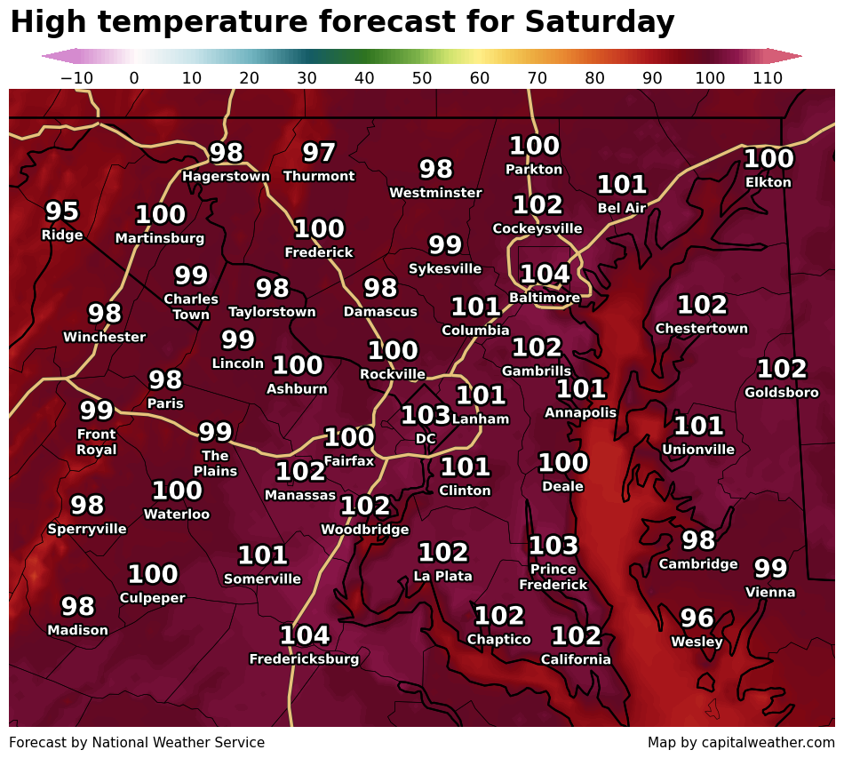
Computer model data suggests highs will be in the mid-90s to low 100s on Saturday July 4, down only slightly from the upper 90s to around 105 Thursday and Friday.
Because the weather pattern will be starting to shift around July 4, we'll need to watch the potential for showers and thunderstorms. It's too soon to say confidently that there will be storms or pinpoint the timing, but the odds of some rain should increase compared to earlier in the week, when high pressure will suppress storm chances.
Our current forecast for the Fourth: Partly sunny and oppressively hot and humid with highs in the upper 90s to low 100s – threatening DC's record high of 100 for the date – and some potential for scattered late-afternoon or early-evening thunderstorms. With the humidity, it could feel as hot as 105 to 110 in the afternoon.
Evening temperatures could range anywhere from the low 90s to the low 80s – the cooler end of that being more likely if and where a storm comes through.
Because July 4 is still five days away, this forecast could still shift a bit – both the temperature forecast but especially the storm forecast. As the holiday draws closer, we'll keep this story updated with our latest forecast and confidence level.
Looking back at July 4 weather history, here are some stats of note:
- Average high: 89
- Record high: 100 in 1919
- Coldest high: 68 in 1941
- Record low: 52 in 1907
- Warmest low: 80 in 2018
- Rainiest: 2.18 inches in 2004


