


As we close in on the Wednesday start of an unusually intense and long-lasting blast of extreme heat extending into the Fourth of July weekend, computer models continue to pump out numbers that could threaten all-time high temperature records in the DC area and across the Mid-Atlantic by late this week.
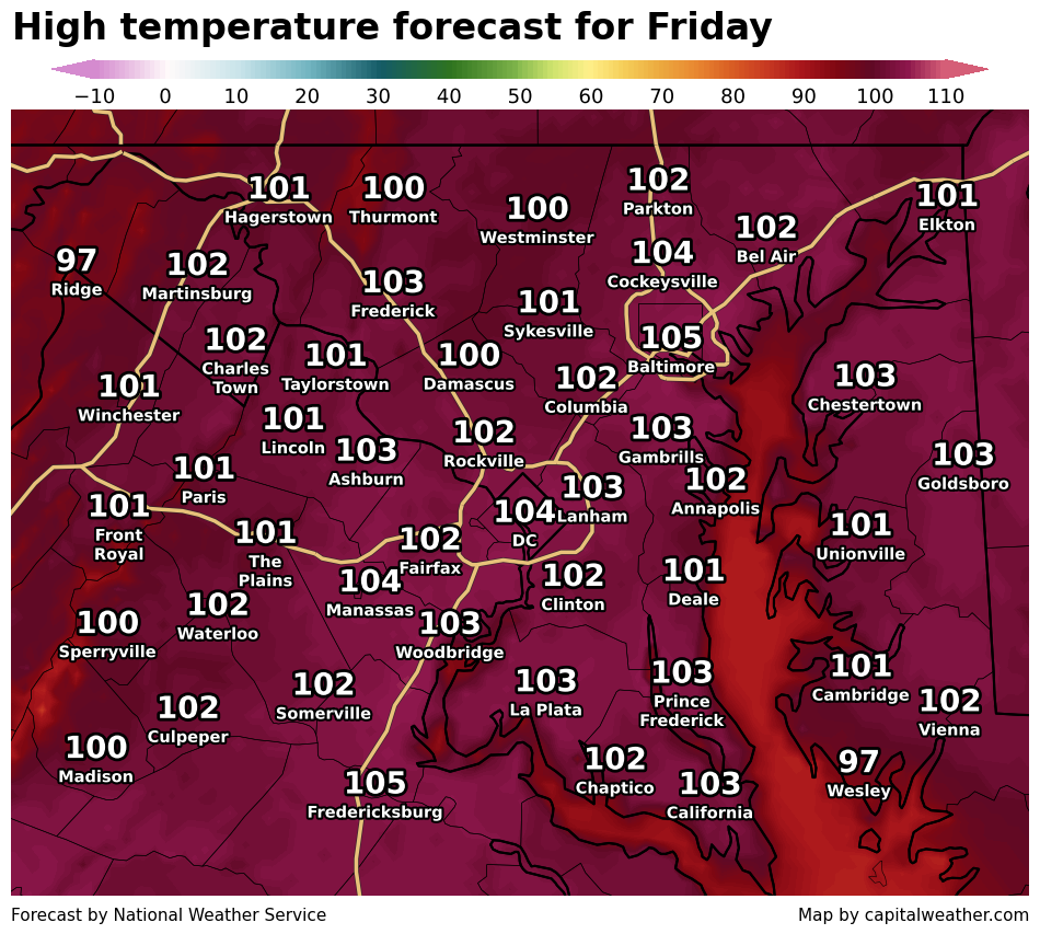
The peak of the heat looks to be Friday as of now, although each day Wednesday through at least Saturday has potential to be dangerously hot. All may shoot for near and beyond 100 degrees, and with the humidity it could feel as hot as 105 to 115. Heat advisories are posted Wednesday with the most significant extreme heat warnings anticipated after that.
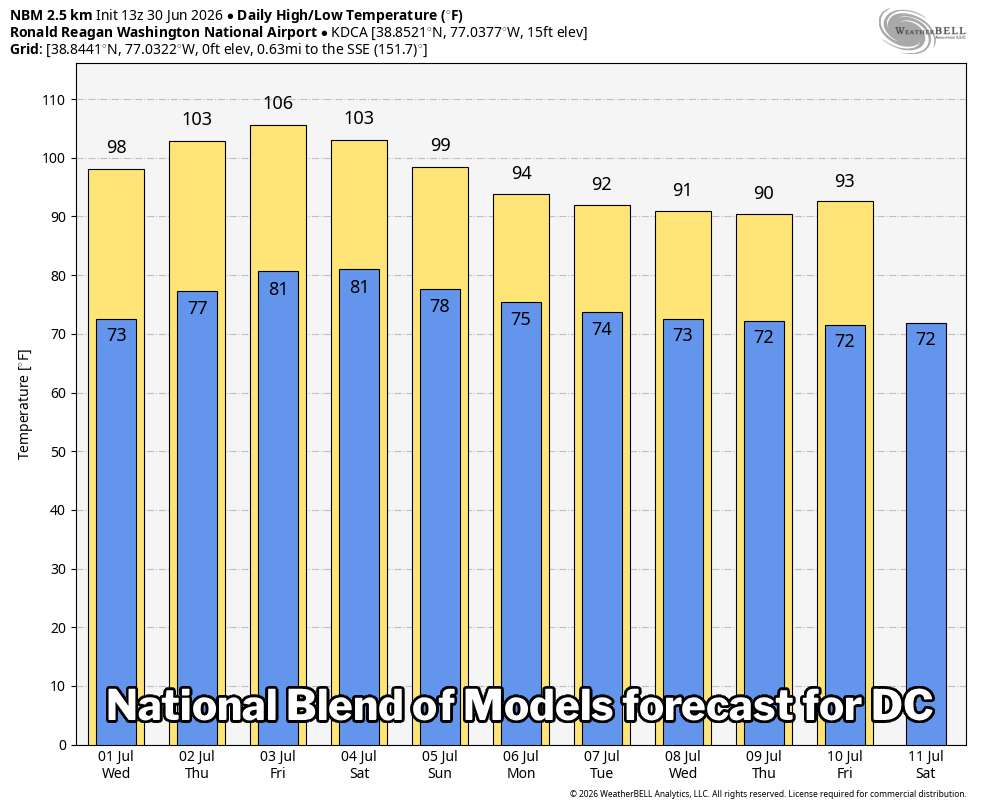
One particular model shown below, which is actually a blend of various models, forecasts highs of 98, 103, 106, 103, 99, and 94 Wednesday through Monday. Both the European and American models are predicting highs up to 109 degrees, but they can sometimes overestimate by a few degrees.
Lots of records could be set
Some locations, like Dulles Airport, will be threatening record highs as soon as Wednesday. Others probably wait until Thursday.
In DC, where weather data is available back to 1872, records could be reached or surpassed Thursday through Saturday, both for daytime highs and warm overnight lows.
| Daily temperature records, July 1-4 | |||
| DC | Dulles | Baltimore | |
| Wed July 1 |
102 (1901) 79 (1977) |
96 (2012) 72 (2017) |
103 (1901) 80 (1933) |
| Thu July 2 |
101 (1898) 79 (2012) |
98 (1966) 75 (2022) |
103 (1901) 80 (1901) |
| Fri July 3 |
101 (1966) 80 (2018) |
103 (1966) 73 (2018) |
104 (1898) 80 (1898) |
| Sat July 4 |
100 (1919) 80 (2018) |
97 (2022) 75 (2018) |
100 (2002) 78 (1911) |
| Daily record highs and record warm lows. Years indicate most recent occurrence. | |||
Some keys to remember:
- DC's all-time high temperature is 106, set in 1918 and 1930.
- The Fourth of July's record high in the District is 100.
- DC's longest streak of 100s on record is four consecutive days.
Other all-time highs in the region include:
- 107 in Baltimore, Maryland
- 107 in Charlottesville, Virginia
- 106 in Annapolis, Maryland
- 105 at Dulles Airport
- 100 in Damascus, Maryland
Punishing and long duration
It's not just peak temperatures approaching all-time highs but the longevity of heat through day and night that will be problematic. Overnight lows may not drop below 75 to 80 for several nights, with heat indexes never dropping much or at all below 90 in urban centers. This means those without housing or air conditioning never have an opportunity to cool down.
And the daytime heat index will probably become truly obscene, even with humidity perhaps being kept down a bit thanks to ongoing drought conditions and the expected position of high pressure. With dew points near to above 70, daytime heat indexes reaching around 105 to 115 could be in play Wednesday through at least Saturday.
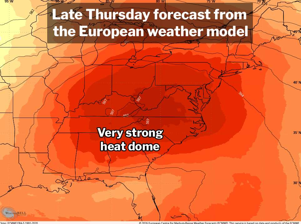
The main cause of this extreme situation is a so-called heat dome of high pressure that will set up across the Midwest, Southeast, and Mid-Atlantic. Temperatures are also boosted by human-caused climate change, something occurring all across the globe, recently highlighted by an historic heat wave in Europe.
The heat should relent to more typical summer levels as we get into early next week.
📬 Get our forecast in your inbox
Our morning forecast email is back! It's included with every level of support — from Free to Founder — delivered 7 days a week. Sign up at: capitalweather.com/support-us


