


Pack away your jackets and break out the bathing suits, sunscreen, and hats.
We declare spring over and summer underway.
The transition happened quickly. The tail end of May and opening days of June offered one last taste of spring, with highs mostly in the 70s and crisp morning lows in the 40s and 50s. But summerlike weather has now taken hold.
Temperatures soared into the 80s on Wednesday and Thursday, and forecast highs are expected to remain in the 80s and 90s for at least the next two weeks.
This year's summer declaration comes a little later than average. Over the past decade or so, we've typically made the call in late May.
Reviewing spring
Looking back at March through May, this spring wasn't especially pleasant or unpleasant. But the season had a hard time finding a rhythm.
Wild swings were common. Over the three-month period, we experienced a whopping eight temperature drops of 30 degrees or more within 24 hours.
"The 'big one' occurred from March 11 to March 12. when Washington saw a record high of 86 one day and snow the next, with temperatures falling to 33," tweeted Capital Weather's Ian Livingston.
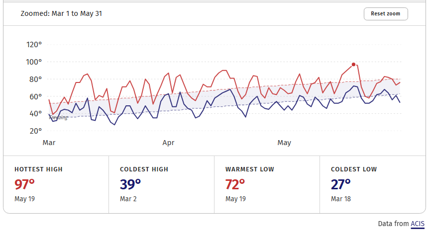
Just two weeks ago, the high temperature plunged 33 degrees between May 20 and 21, from 96 to 63.
Despite all the swings, warmer-than-normal weather was much more common than cold. March and April finished 5.1 and 3.8 degrees above normal, respectively, while May was 1.4 degrees below normal. The average temperature for the March-through-May period was 60.1 degrees, making it the sixth-warmest spring on record.
Six of the seven warmest springs on record have occurred since 2010, another sign of our warming climate.
Despite the temperature volatility, storminess was kept in check. March, April and May all featured rainfall deficits of at least an inch, and the three-month period ranked as the 11th driest on record. The persistent lack of rain is a major driver of the moderate to severe drought affecting the area.
What's next
The tendency for warmer- and drier-than-normal weather appears likely to persist well into June. Above-normal temperatures are favored through at least the next two weeks.
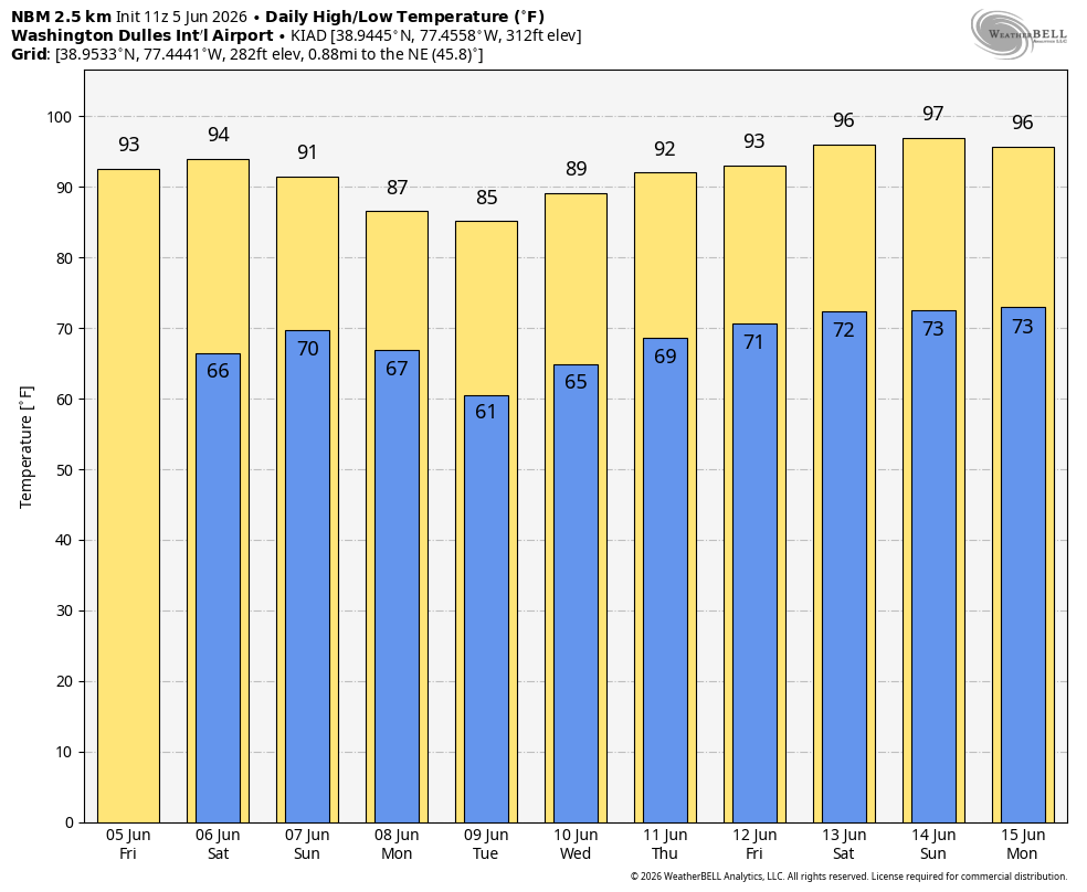
There's no immediate sign of a major rainstorm, although the pattern may turn somewhat wetter between June 15 and 20.
Our summer outlook, released earlier this week, projects slightly above-normal temperatures and slightly below-normal rainfall overall.
Ian Livingston contributed to this report.


